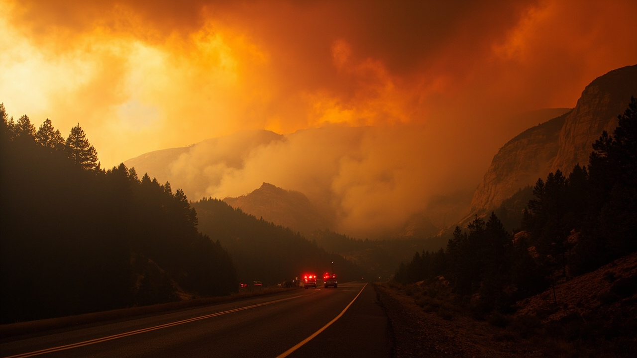
TL;DR: Evacuations were ordered for Oak Creek Canyon and visitors to End/Edge of the World were told to leave after the Pocket Fire was reported at 5 p.m. on June 19 about 7 miles north of Sedona, with State Route 89A closed between Fort Tuthill and the north end of Sedona.
Evacuation order covers Oak Creek Canyon visitors and residents
Evacuations have been ordered due to the Pocket Fire in the Oak Creek Canyon area, according to Coconino National Forest | Evacuations of Oak Creek Canyon ordered due to Pocket Fire north of Sedona | Forest Service.
Forest visitors in the Oak Creek Canyon area were asked to evacuate.
Visitors to End/Edge of the World were also asked to evacuate.
The Coconino County Sheriff's Office issued the "Go" order for residents and visitors between Sedona and Forest Highlands on Friday evening, according to Wildfire north of Sedona prompts evacuation orders for Oak Creek Canyon.
That order applied to Oak Creek Canyon and areas up to Forest Highlands south of Flagstaff.
The county order also covered dispersed camping near West Fork and nearby areas above the rim, according to Evacuations ordered as Pocket Fire grows near Sedona.
Coconino County's online evacuation-zone map showed Oak Creek Canyon 14 and Oak Creek Canyon 15 zones under "go" evacuation status along State Route 89A north of Sedona toward Forest Highlands, according to Evacuations ordered as Pocket Fire grows near Sedona.
The latest evacuation information can be obtained from Coconino County at coconino.az.gov/ready, according to Coconino National Forest | More resources arrive to battle Pocket Fire north of Sedona | Forest Service.
Residents were advised to sign up for emergency alerts at https://www.coconino.az.gov/ready, according to Evacuations ordered as Pocket Fire grows near Sedona.
An evacuation shelter was open at Red Rock Jr. High School at 995 Upper Red Rock Loop Road in Sedona, according to Evacuations ordered as Pocket Fire grows near Sedona.
The American Red Cross Arizona announced the shelter opening on June 20.
Red Cross Arizona officials said the evacuation center had been set up at Red Rock Jr. High School, according to Pocket Fire: Massive multi-agency response unites to defend Sedona and Oak Creek Canyon | FOX 10 Phoenix.
Four people were at the shelter during the prior night, according to that FOX 10 Phoenix reporting.
State Route 89A closed from Fort Tuthill to Sedona
State Route 89A is closed between Fort Tuthill and the north end of Sedona, according to Coconino National Forest | Evacuations of Oak Creek Canyon ordered due to Pocket Fire north of Sedona | Forest Service.
As of noon on June 20, State Route 89A was closed in both directions between south Flagstaff and the north end of Sedona, according to Evacuations ordered as Pocket Fire grows near Sedona.
Arizona Department of Transportation officials said there was no estimated time for reopening.
The latest road closure information can be obtained from the Arizona Department of Transportation at az511.com, according to Coconino National Forest | More resources arrive to battle Pocket Fire north of Sedona | Forest Service.
Real-time highway conditions were available through ADOT's traveler information website at AZ511.com, the az511 app, or by calling 511, according to Evacuations ordered as Pocket Fire grows near Sedona.
Travel down Woody Mountain Road, identified as Forest Road 231, was not advised at the time of the first Forest Service evacuation release.
Officials later reported that Woody Mountain Road, or Forest Road 231, was closed past Forest Road 536, according to Coconino National Forest | More resources arrive to battle Pocket Fire north of Sedona | Forest Service.
Officials advised against travel on Woody Mountain Road, also known as Forest Road 231, according to Evacuations ordered as Pocket Fire grows near Sedona.
A formal closure order for the area surrounding the Pocket Fire was expected to be established soon.
Fire reported June 19 north of Sedona
The fire was first reported at 5 p.m. on June 19, according to Coconino National Forest | Evacuations of Oak Creek Canyon ordered due to Pocket Fire north of Sedona | Forest Service.
The initial Forest Service evacuation release described it as a 100-acre wildfire located 7 miles north of Sedona in the Oak Creek Canyon area.
The Pocket Fire was first reported above the western rim of Oak Creek Canyon in the Red Rock-Secret Mountain Wilderness, according to Wildfire north of Sedona prompts evacuation orders for Oak Creek Canyon.
According to InciWeb, it was estimated at 500 acres at about 9:20 p.m. Friday evening.
The follow-up Forest Service release on June 20 described it as the roughly 500-acre Pocket Fire located about 7 miles north of Sedona in the Oak Creek Canyon area.
The wildfire was burning about 7 miles north of Sedona after first being reported at about 5 p.m. June 19, according to Evacuations ordered as Pocket Fire grows near Sedona.
The Pocket Fire was initially reported at 100 acres on the morning of June 20, and officials said by 9 a.m. it had grown to 500 acres.
It was burning through timber and brush.
Its cause was undetermined, according to Coconino National Forest | More resources arrive to battle Pocket Fire north of Sedona | Forest Service.
Its cause was also described as unknown in Evacuations ordered as Pocket Fire grows near Sedona.
Initial attack forces and full-suppression strategy
Resources assigned to the fire in the first evacuation release included two Hotshot crews, one dozer, five engines and miscellaneous overhead, with more en route, according to Coconino National Forest | Evacuations of Oak Creek Canyon ordered due to Pocket Fire north of Sedona | Forest Service.
As of about 7 p.m. Friday, two hotshot crews, one dozer and five engines as well as aircraft had been assigned, with more resources on the way, according to Wildfire north of Sedona prompts evacuation orders for Oak Creek Canyon.
Firefighters were responding with a direct extinguishment and full suppression strategy.
Coconino National Forest officials said firefighters were responding with a direct extinguishment and full suppression strategy, according to that KNAU report.
Firefighters were using a full-suppression strategy, according to Evacuations ordered as Pocket Fire grows near Sedona.
The suppression strategy includes use of a direct extinguishment strategy to confine the fire to as small a perimeter as possible as quickly as possible, according to Coconino National Forest | More resources arrive to battle Pocket Fire north of Sedona | Forest Service.
Firefighters will take a direct approach against the edge of the fire by building containment lines when and where it is safe to do so.
Firefighters will use indirect confinement tactics, such as firing operations, where necessary to provide for firefighter safety.
Larger force arrives June 20 with air support
More resources arrived to help with suppression efforts on June 20, according to Coconino National Forest | More resources arrive to battle Pocket Fire north of Sedona | Forest Service.
Resources assigned then included seven Hotshot crews, one dozer, 13 engines, miscellaneous overhead, six helicopters and air attack, with more expected to arrive over the course of that day.
Resources assigned to the fire scaled up and included six total helicopters, with air tankers to be used as needed, according to Pocket Fire: Massive multi-agency response unites to defend Sedona and Oak Creek Canyon | FOX 10 Phoenix.
The response grew to seven Hotshot crews, 13 engines, a dozer, six helicopters and an air attack aircraft, according to Evacuations ordered as Pocket Fire grows near Sedona.
Arizona Department of Forestry and Fire Management sent about 20 engines, five water tenders and an ambulance to support firefighters, according to that Arizona Republic reporting.
Northern Arizona Type 3 Incident Management Team assumed command of the fire at 6 a.m. on June 20, according to Coconino National Forest | More resources arrive to battle Pocket Fire north of Sedona | Forest Service.
Southwest Area Incident Management Team 2 had been ordered to assume command shortly afterward.
The Northern Arizona Type 3 Incident Management Team assumed command the morning of June 20, according to Evacuations ordered as Pocket Fire grows near Sedona.
Other crews on scene included personnel from Coconino National Forest, Sedona Fire District, Sedona police, Arizona Department of Transportation, Arizona Department of Public Safety and sheriff's offices in Coconino and Yavapai counties, according to the Sedona Fire Department as reported in that Arizona Republic account.
The extensive multi-agency list also included the City of Sedona, Sedona Police Department, Yavapai County Sheriff's Office, City of Flagstaff, Arizona Game and Fish, Camp Navajo Fire Department and Highlands Fire District, according to Pocket Fire: Massive multi-agency response unites to defend Sedona and Oak Creek Canyon | FOX 10 Phoenix.
Dozer line, retardant and weekend fire behavior
Firefighters spent Friday evening using a dozer to establish fire line on the northeast side of the fire perimeter, according to Coconino National Forest | More resources arrive to battle Pocket Fire north of Sedona | Forest Service.
Aerial resources were used to drop retardant on the east portion of the fire.
Fire behavior remained active late into Friday night.
Dry and windy conditions expected throughout the weekend were likely to exacerbate fire behavior.
Firefighters faced a drying trend and southwest winds expected to reach 15 to 25 mph, with gusts up to 35 mph across much of the high terrain from the Mogollon Rim northward Saturday, according to the forecast cited in Evacuations ordered as Pocket Fire grows near Sedona.
Firefighters established a dozer line north and east of the fire, with operations continuing farther west on Saturday, according to Pocket Fire: Massive multi-agency response unites to defend Sedona and Oak Creek Canyon | FOX 10 Phoenix.
Crews planned to spend Saturday holding and strengthening dozer line constructed the prior night while bringing that line in a northwest direction, according to Coconino National Forest | More resources arrive to battle Pocket Fire north of Sedona | Forest Service.
Aviation resources were to continue working on the eastern perimeter.
Protection priorities around Oak Creek Canyon
Incident objectives included keeping the fire west of State Route 89A, south of Forest Road 535 and south and east of Forest Road 231, according to Coconino National Forest | More resources arrive to battle Pocket Fire north of Sedona | Forest Service.
Firefighters were also working to protect East Pocket Lookout Tower.
Firefighters positioned at both Slide Rock State Park and Seven Canyons Golf Club were working to protect values at risk in Oak Creek Canyon.
Engine crews were in Slide Rock evaluating the area and starting prep work, while the fire was not moving into Oak Creek Canyon as of that report, according to Pocket Fire: Massive multi-agency response unites to defend Sedona and Oak Creek Canyon | FOX 10 Phoenix.
Precautionary prep work was also underway at Seven Canyons Resort in case the fire moved farther south toward Sedona.
Flight restriction and outdoor readiness lessons
A Temporary Flight Restriction was in effect surrounding the fire area, according to Coconino National Forest | More resources arrive to battle Pocket Fire north of Sedona | Forest Service.
The public was asked to refrain from nearby drone use.
Drones pose a serious risk to firefighters and can impede aerial firefighting operations.
For outdoor travelers, the immediate lesson is to leave an evacuation zone promptly when a "Go" order is issued and to check county and transportation sources before returning.
Keep evacuation routes, shelter locations and emergency alert registrations confirmed before entering canyon country during fire season.
Those steps reflect the Pocket Fire pattern of rapidly changing size estimates, road closures and shelter activation within hours of the first report.